The beaches, dunes, and sandy areas of Brazil have been modified over the past 36 years. This is shown by the latest analysis from MapBiomas using satellite images from 1985 to 2020. The reduction was 15%, or about 70 thousand hectares. Thirty-six years ago, there were 451 thousand hectares; in 2020, only 382 thousand hectares remained. In addition to dunes, beaches, and sandy areas, the study presented by MapBiomas on this day, October 27th, On YouTube, also assesses the dynamics of mangrove areas, salt marshes (salinized areas devoid of vegetation), and aquaculture/salt farming."
The preservation of beaches and dunes is essential for controlling coastal erosion and preserving the coastal strip and its biodiversity. Beaches and dunes typically protect mangroves from wave action. They create a calm environment where mud can be deposited and colonized by mangrove vegetation.
The reasons for the decrease in the surface area of dunes, beaches, and continental sandy areas are varied: from revegetation of the dune tops, occupation by aquaculture and salt farming enterprises, to the expansion of invasive species. The reduction in beach and dune areas can also be partly explained by strong real estate pressure. Additionally, there is low protection: only 40% of this type of deposit is protected within some conservation unit. Among the cases of land use occupation, the advancement of pine trees over dune fields in Rio Grande do Sul in areas bordering planted forests and the expansion of aquaculture/salt farming structures in the coastal region of Rio Grande do Norte are noteworthy.
"Due to the Lençóis Maranhenses National Park and the Maranhenses Reentrâncias Environmental Protection Area, Maranhão leads in the protection of dunes/beaches and mangroves, respectively," says Pedro Walfir, general coordinator of the coastal zone theme at MapBiomas. Almost all (98% - 99 thousand hectares) of its beaches, dunes, and sandy areas, 96% (24 thousand hectares) of its salt marshes, and 86% (398 thousand hectares) of Maranhão's mangroves are protected by Conservation Units. "Therefore, Maranhão is the state with the largest extent of coastal environments protected by CUs in the country and one of the most preserved," explains Pedro Walfir."
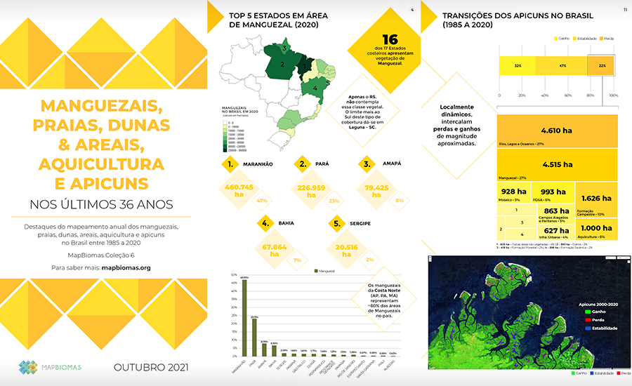
From 1985 to 2020, mangrove areas in the country remained relatively stable, going from 946 thousand hectares to 981 thousand hectares. However, from the year 2000 to 2020, a 2% retraction in mangrove areas is observed. In Brazil, over 78% of the mangrove area is concentrated on the Amazon coast, stretching from Amapá to Maranhão, housing the most well-preserved and extensive mangroves on the continent. On the other hand, it is in the Northeast and Southeast regions, smaller in extension, where mangroves are more threatened. In both regions, from 2000 to 2020, direct anthropogenic actions were responsible for 13% of changes in this coverage.
The mangrove is the nursery for countless marine species: 70 to 80% of the fish, crustaceans, and mollusks consumed by the population rely on the biome at some stage of their lives. Several species of economically important fish use mangroves as breeding grounds and then return to the sea.
In this context, the creation of Conservation Units in coastal zones protecting mangroves has been of undeniable importance. Brazil has 340 (13%) of its total of 2,544 Conservation Units in the coastal zone. Currently, 75% of the mangrove area in the country is within Conservation Units, which should contribute to the future preservation of one of the most threatened ecosystems on the planet.
From an ecosystem perspective, salt marshes (apicuns) are intrinsically related to mangroves, which tend to grow on these hypersaline tidal flats - hence the importance of their conservation for the future of mangroves. Currently, just over half of the salt marshes (56%) are also within conservation units. On the other hand, the current use of much of Brazil's salt marshes for salt and shrimp production poses a risk to mangrove conservation. Because they are open and flat areas, salt marshes are preferred for commercial salt and crustacean production, especially shrimp. From 1985 to 2020, the area of aquaculture and salt farming saw a 39% jump, from 36 thousand hectares to 59 thousand hectares. Meanwhile, salt marshes saw a 12% reduction between 2000 and 2020, decreasing from 65 thousand hectares to 57 thousand hectares.
It is also noteworthy that 8% of the national aquaculture is located within Conservation Units. 'In these cases, it is important to check whether these activities are in areas that allow commercial exploitation and whether they strictly follow Brazilian legislation,' warns César Diniz, technical coordinator of the MapBiomas Coastal Zone mapping. The mapping shows that the state with the most aquaculture/salt farming area within Conservation Units is Rio Grande do Norte (2.5%, or 1,039 hectares), a state that concentrates 67% of the country's salt farming/aquaculture area.
Check out more highlights of Coastal Zone data here.