

VALIDATION POINTS
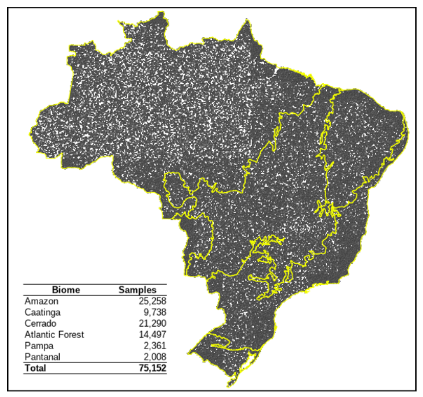
A total of 85,152 random stratified samples were generated to validate MapBiomas' annual land cover and land use maps of Brazil. The samples were visually inspected using Landsat images, assigning the land use and land cover class for each year from 1985 to 2022.
DOWNLOAD THE VALIDATION POINT DATASET
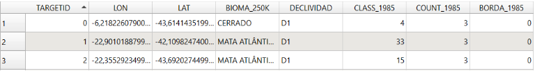
This set of samples are available in the following files csv, xlsx and shapefile. Each sample presents coordinates, biomes, declivity, municipality/UF and informations by year of: land cover and use classe in the column 'CLASS_'(código/ID da legenda used in the maps); interpreter agreement level in the column 'COUNT_'(3:maximum, 2:medium and 1:low) and edge pixel between two classes in the column 'BORDA_'(1:yes and 0:no). There are also the probability data and the sample weights.
UNDERSTAND HOW THE SAMPLES WERE COLLECTED
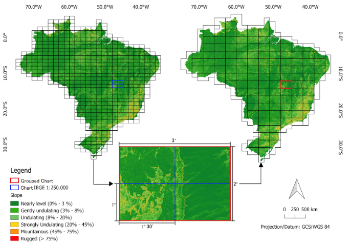
The stratification of the samples was done on two levels: by supercards (joining every four IBGE maps of 1:250,000) and by slope classes defined by EMBRAPA. Considering the minimum quantity of 500 points per supercharter and corrected with the Bonferroni equation. Dimensioned so as to ensure a maximum margin of error of 5% and confidence level of 95% in the smallest unit of geographical coverage, in other words, in each supercharter. For the national territory the maximum expected error was 0.5%
For the visual interpretation the TVI (Temporal Visual Inspection) platform was used, developed by Lapig, in which each pixel was initially interpreted by 3 independent analysts. Pixels for which there was no agreement between the assigned classes were re-inspected by supervisor and the pixel's class assigned.

In Collection 7, these points have been updated for the years 2019, 2020 and 2021 and, in the Collection 8, for the year of 2022, as well as adjusted for new legend classes.
For more information about the content description and sample method, access the ATBD. Another reference material on samples and reference points analysis are available in the article.
For questions, suggestions and other information please contact contato@mapbiomas.org and participate in the MapBiomas Forum.