

The MapBiomas survey found that the area of annual crops tripled between 1985 and 2020
The growth of agriculture between 1985 and 2020 is impressive: mapped areas of some annual crops, such as soybeans and corn, tripled; perennial crops, such as coffee and citrus, had similar expansion (2.7 times); in the case of silviculture, the growth was five times. These are some of the data obtained by MapBiomas through the analysis of satellite images between 1985 and 2020. The survey was presented on October 20th on YouTube On YouTube. It includes new land use categories: in addition to soybeans and sugarcane, data on some mapped areas of coffee and citrus, as well as data on central pivot irrigation and irrigated rice, will be presented.
The total mapped agriculture area in Brazil increased from 19 million hectares in 1985 to 55 million hectares in 2020. Of this total, 36 million hectares are soybeans. Alone, soybeans occupy 4.3% of the national territory - an area equivalent to the entire Republic of Congo and larger than countries like Italy, Vietnam, or Malaysia. Half of this total is in the Cerrado, where it has expanded over 16.8 million hectares in the last 36 years.
The total area occupied by agriculture is even larger. In addition to the areas directly mapped as agricultural cultivation, there is an undefined fraction of the areas mapped as a mosaic of agribusiness (45.3 million hectares) that also include non-perennial agricultural crops as well as part of the perennial crop areas such as coffee, cocoa, and citrus that have not yet been mapped. The same applies to silviculture, which has a 30% omission rate, referring to areas that may still be classified as forest or agribusiness mosaic.
In the Amazon, the growth of soybeans began in the early 2000s and totaled 5.2 million hectares, or 14% of the national total. There, the recent expansion into native vegetation can be observed in the 'lavrado' - an area with cerrado-like characteristics that exists within the biome in the state of Roraima. Another 26% of the country's soybean area is in the Atlantic Forest, where soybeans expanded by 7.9 million hectares between 1985 and 2020.
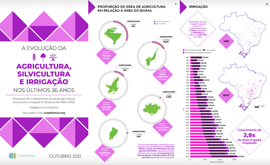
The growth of the area occupied by agriculture can be observed in all Brazilian biomes, but more pronouncedly in the Cerrado: the most recent data shows that almost half (42%) of Brazil's agriculture is in the Cerrado. Between 1985 and 2020, the agriculture area in the Cerrado grew by 464%. In second place is the Atlantic Forest, representing 34% of the agriculture area, followed by the Amazon and Pampa, each with 11%. The Pampa is the biome with the largest share of mapped agriculture territory (31%).
According to related studies, the Cerrado, the biome with the highest agricultural growth and the largest area dedicated to this activity, is also one of the most vulnerable to changes in rainfall patterns caused by deforestation in the Amazon. It is also one of the regions at greatest climate risk. The latest IPCC report predicts a 20% reduction in precipitation in Central Brazil and a temperature increase of 4°C to 5°C - a scenario that will compromise current agricultural activities in the region.
Within the Cerrado, the land occupation dynamics vary between states with longer-established areas and the Matopiba region, which has more recent occupation. Along the border between the states of Maranhão, Tocantins, Piauí, and Bahia, the expansion of agriculture into native vegetation is more intense. Between 2000 and 2020, considering intervals of 5 years, 76% of the agricultural expansion in the region occurred on native vegetation; in other states of the biome, this percentage is less than 10% over the same period.
In general, what is observed in all biomes is that there is no need to convert natural vegetation into arable land because there is already plenty of open land with agricultural potential, and the Cerrado is no exception," says Moisés Salgado, from the MapBiomas team responsible for agriculture surveying and technology director at Agrosatélite. "With the exception of the Amazon and Atlantic Forest, the other biomes have few demarcated conservation units, which makes landscape recovery work difficult. This reinforces the need for conservation of the remaining native vegetation areas, especially in the Cerrado, which has already lost half of its original cover," he emphasizes.
The evolution of mapped irrigated areas shows a growth of 293%, increasing from 819 thousand hectares in 1985 to 3.217 million hectares in 2020. The area irrigated by center-pivot irrigation systems, which accounted for only 8.5% of the total irrigated area in 1985, is responsible for 45.7% in 2020. During this period, the country's water surface area decreased by 3.1 million hectares. Since the early 1990s, Brazil has lost 15% of its water surface area. The hydrographic basins with the highest index of center-pivot irrigation water use are Paracatu (MG), Alto São Francisco (BA), and Alto Paranapanema (SP), all experiencing a reduction in water surface area over the last three decades.
"Although irrigation is the alternative for farmers when there is a water deficiency, it is not authorized during crises, such as the one the country is currently facing," explains Moisés. "The trend is a decrease in water availability in Brazil, so a more conservative use of water in agriculture is crucial for the future success of the activity," he concludes.
Other crops
The MapBiomas survey shows that, in the case of sugarcane, the mapped area grew by 291% between 1985 and 2020, when this crop occupied 9 million hectares - equivalent to one-quarter of the soybean area.
The coffee areas were mapped in states with the largest planted area, such as Minas Gerais, Espírito Santo, São Paulo, Bahia, Paraná, and Goiás. In total, the mapped area grew by 43% in the last three decades, reaching 804 thousand hectares in 2020.
The citrus survey was conducted in the state of São Paulo and shows a total of 31 thousand hectares in 2020.
Silviculture, which had a fivefold growth in mapped area, went from 1.4 million hectares in 1985 to 7.5 million hectares in 2020. The states with the largest mapped area of silviculture are Minas Gerais, Paraná, and Santa Catarina.
See the main highlights of agriculture, forestry, and irrigation aqui.
Watch the event with the presentation of the data: