Garimpo já ocupa uma área maior que mineração industrial e avança sobre terras indígenas e unidades de conservação na Amazônia
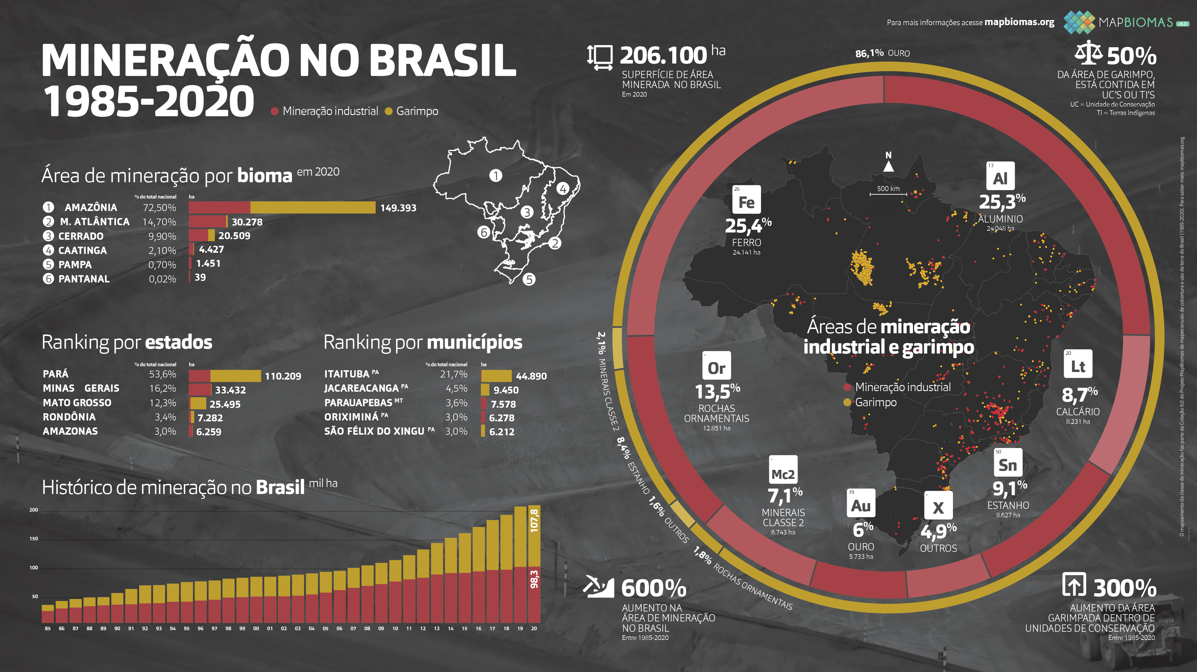
Entre 1985 e 2020 a área minerada no Brasil cresceu seis vezes, segundo a mais recente análise temporal do território brasileiro feita pelo MapBiomas. O dado, que resulta da análise de imagens de satélite com o auxílio de inteligência artificial, expressa o salto de 31 mil hectares em 1985 para um total de 206 mil hectares no ano passado. Boa parte desse crescimento se deu mediante a expansão na floresta amazônica.
Em 2020, três de cada quatro hectares minerados no Brasil estavam na Amazônia. O bioma concentra 72,5 % de toda a área, incluindo a mineração Industrial e o garimpo. São 149.393 ha; destes, 101.100 ha (67,6%) são de garimpo. A quase totalidade (93,7%) do garimpo do Brasil concentra-se na Amazônia. No caso da mineração industrial, o bioma responde por praticamente a metade (49,2%) da área ocupada por essa atividade no País.
Além de se concentrar na Amazônia, o garimpo caracteriza-se também pela forte expansão em anos mais recentes. A atividade garimpeira superou a área associada à mineração industrial em 2020: 107.800 ha contra 98.300, respectivamente. Enquanto a expansão da mineração industrial se deu de forma incremental e contínua, a um ritmo de 2,2 mil ha por ano e sem grandes variações entre 1985 e 2020. No caso do garimpo, a situação foi outra: entre 1985 e 2009 o ritmo de crescimento era baixo, em torno de 1,5 mil ha por ano, mas a partir de 2010 a taxa de expansão quadruplicou para 6,5 mil ha por ano.
A expansão do garimpo coincide com o avanço sobre territórios indígenas e unidades de conservação. De 2010 a 2020, a área ocupada pelo garimpo dentro de terras indígenas cresceu 495%; no caso das unidades de conservação, o crescimento foi de 301%. No ano passado, metade da área nacional do garimpo estava em unidades de conservação (40,7%) ou terras indígenas (9,3%). As maiores áreas de garimpo em terras indígenas estão em território Kayapó (7602 ha) e Munduruku (1592 ha), no Pará, e Yanomami (414 ha), no Amazonas e Roraima. Entre as 10 unidades de conservação com maior atividade garimpeira, oito ficam no Pará. As três maiores são a APA do Tapajós (34.740 ha), a Flona do Amaná (4.150 ha) e o Parna do Rio Novo (1.752 ha).
“Pela primeira vez, a evolução das áreas mineradas é apresentada para a sociedade, mostrando a expansão de todo o território brasileiro desde 1985. Tratam-se de dados inéditos que permitem compreender as diferentes dinâmicas das áreas de mineração industrial e garimpo e suas relações, por exemplo, com os preços das commodities, com as unidades de conservação e terras indígenas”, afirma Pedro Walfir, professor da UFPA e coordenador do Mapeamento de Mineração no MapBiomas.
Em extensão de área total minerada, os três maiores estados são Pará (110.209 ha), Minas Gerais (33.432 ha) e Mato Grosso (25.495 ha). No caso do Pará, a maior parte dessa área é ocupada pelo garimpo (76.514 ha, contra 33.695 há de mineração industrial). Em Minas Gerais, a quase totalidade é ocupada pela mineração industrial (32.785 ha). O Mato Grosso repete o padrão do Pará, com predominância do garimpo (22.987 ha).
Quando a área industrial e garimpeira são somadas, apenas 2 estados são estão presentes no ranking dos 10 municípios de maior área minerada: PA, MT. O primeiro, segundo e terceiro lugar – Itaituba (44.854 ha), Jacareacanga (9.450 ha) e Parauapebas (7.558 ha) – ficam no Pará. O sexto – Peixoto de Azevedo (5.736 ha) – fica no Mato Grosso. Minas Gerais fica de fora do ranking municípios de maior área minerada, quando agrupadas as áreas de garimpo e mineração industrial.
Municípios
O mapa dos municípios com maior atividade garimpeira é ligeiramente diferente. Sem exceções, todos os 10 municípios com maior área garimpada ficam no sul do Pará e norte de Mato Grosso, com Itaituba, Jacareacanga e São Félix do Xingu em primeiro e segundo e terceiro lugar, respectivamente. Essa concentração não aparece no caso dos dez municípios com maior área minerada industrialmente, que ficam espalhados por Pará, Minas Gerais e Amazonas. Porém as três maiores – Parauapebas (6706 ha), Oriximiná (6278 ha) e Paragominas (5402 ha), ficam todas no Pará, seguidas por relevante contribuição de Minas Gerais, em Paracatu (3116 ha), Itabira (2963 ha) e Congonhas (2405 ha).
Garimpo e mineração industrial diferem também em relação ao fruto da exploração mineral. Enquanto produção de ferro (25,4%) e alumínio (25,3%) respondem por metade da área de mineração industrial, 86,1% da área garimpada está relacionada à extração de ouro.
Em área total minerada, a Amazônia lidera com 72.5 % (149.393 ha), enquanto a Mata Atlântica é o bioma que aparece em um distante segundo lugar, com 14,7% (30.278 ha), seguida pelo Cerrado, com 9.9% (20.509 ha), Caatinga (2,1% – 4.427 ha), Pampa (0,7% – 1.451 ha) e Pantanal – 0.02% (39 ha). Na mineração industrial, a Amazônia contém 49.2 % (48.342 ha) da área total, a Mata Atlântica responde por quase um terço da área ocupada (29,7% – 29.157 ha), seguida pelo Cerrado (15,7% – 15.392 ha), Caatinga (4% – 3.950 ha) e o Pampa (1,5% – 1.451 ha). Com exceção da Amazônia, a área de garimpo não é predominante nos demais biomas: 4,7% (5.117 ha) no Cerrado, 1% (1.121 ha) na Mata Atlântica e 0,4% (477 ha) na Caatinga.
“Os produtos da Mineração são fundamentais para o desenvolvimento de uma economia de baixo carbono. Esperamos que estes dados contribuam para a definição de estratégias para acabar com as atividades ilegais e estabelecer uma mineração em bases sustentáveis respeitando as áreas protegidas e o direito dos povos indígenas e atendendo os mais elevados padrões de cuidado com a biodiversidade, solo e a água”, afirma Tasso Azevedo, Coordenador Geral do MapBiomas.
Acesse os principais dados do levantamento no Fact Sheet aqui.