

The biome experienced a reduction of over 15% in water surface area
The Amazon biome lost 45.2 million hectares of native vegetation between 1985 and 2020 – which is equivalent to 11.6% of its original coverage. The data are part of the annual land cover and land use mapping of the Amazon biome in Brazil, from 1985 to 2020, by MapBiomas.
According to the survey, 82.1% of the Amazon biome is covered by native vegetation, with 62% of the remaining forested areas in the biome located in Protected Areas. Although the percentage of native vegetation seems promising, the total amount of deforestation in the biome has been increasing year by year, losing space to agriculture, urban areas, and mining. Over the past 36 years, the total expansion of urban areas in the Amazon biome was 236,000 hectares, with the state of Pará standing out as the Amazon state with the highest expansion, accounting for one-third of the new urban areas in the biome (34%).
The grassland and savanna formations, belonging to the biome, also face pressure and have lost territory, mainly due to land conversion for agriculture and livestock farming. "The main drivers of native vegetation change are livestock farming and agriculture. Urbanization accounts for a smaller proportion of the area, and mining has a more localized impact. These changes also affect the water surface," explains Carlos Souza Jr., coordinator of MapBiomas Água and researcher at Imazon. According to the survey, between 1985 and 2020, mining expansion in the Amazon biome reached 134,015 hectares, with most of these areas being attributed to artisanal mining.
Another relevant piece of information from the study is that, over 20 years, the Amazon lost more than 19,000 km² of water surface, a reduction of 16.4%. According to the researcher, the main reduction in water surface was occurring in floodplain areas, most of which are distant from the deforestation arc, indicating that the cause may be associated with global warming. "This is a very direct warning sign for Brazilian society, especially decision-makers. The reduction in water affects city water supplies, food production, energy generation, and tourism, with negative consequences for everyone in the country," warns Carlos Souza Jr.
About MapBiomas
MapBiomas is a multi-institutional initiative that brings together universities, NGOs, and technology companies to contribute to the understanding of land transformations in Brazil through annual mapping of land cover and land use. In August 2021, MapBiomas Collection 6 was published, featuring land cover and land use maps of Brazil from 1985 to 2020. The tool developed by MapBiomas for all its initiatives provides information generated with a spatial resolution of 30 meters. The data is processed using automatic classification algorithms through information on the Google Earth Engine cloud.
Follow the main highlights of the Amazon biome.
Download the infographics of the biomes here. 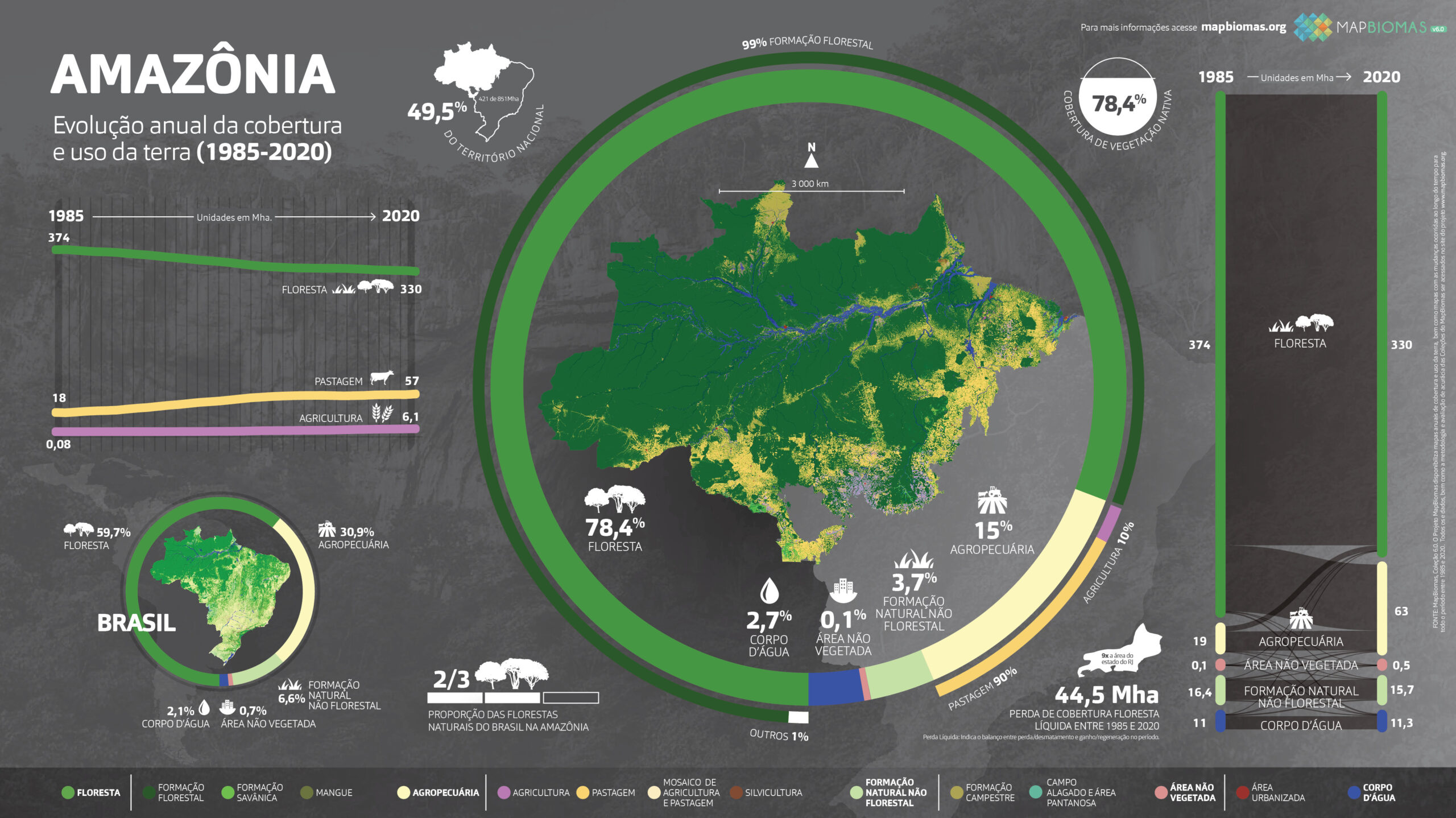
Learn about the webinar on the data from Collection 6 (1985-2020) of the Amazon biome.
https://www.youtube.com/embed/LnlPOlhJu18