

"Bahia quintupled its cultivation area in 36 years, and Piauí tripled its agricultural area since the late 1990s; Tocantins and Maranhão are the states that have lost the most native vegetation in the last decade."
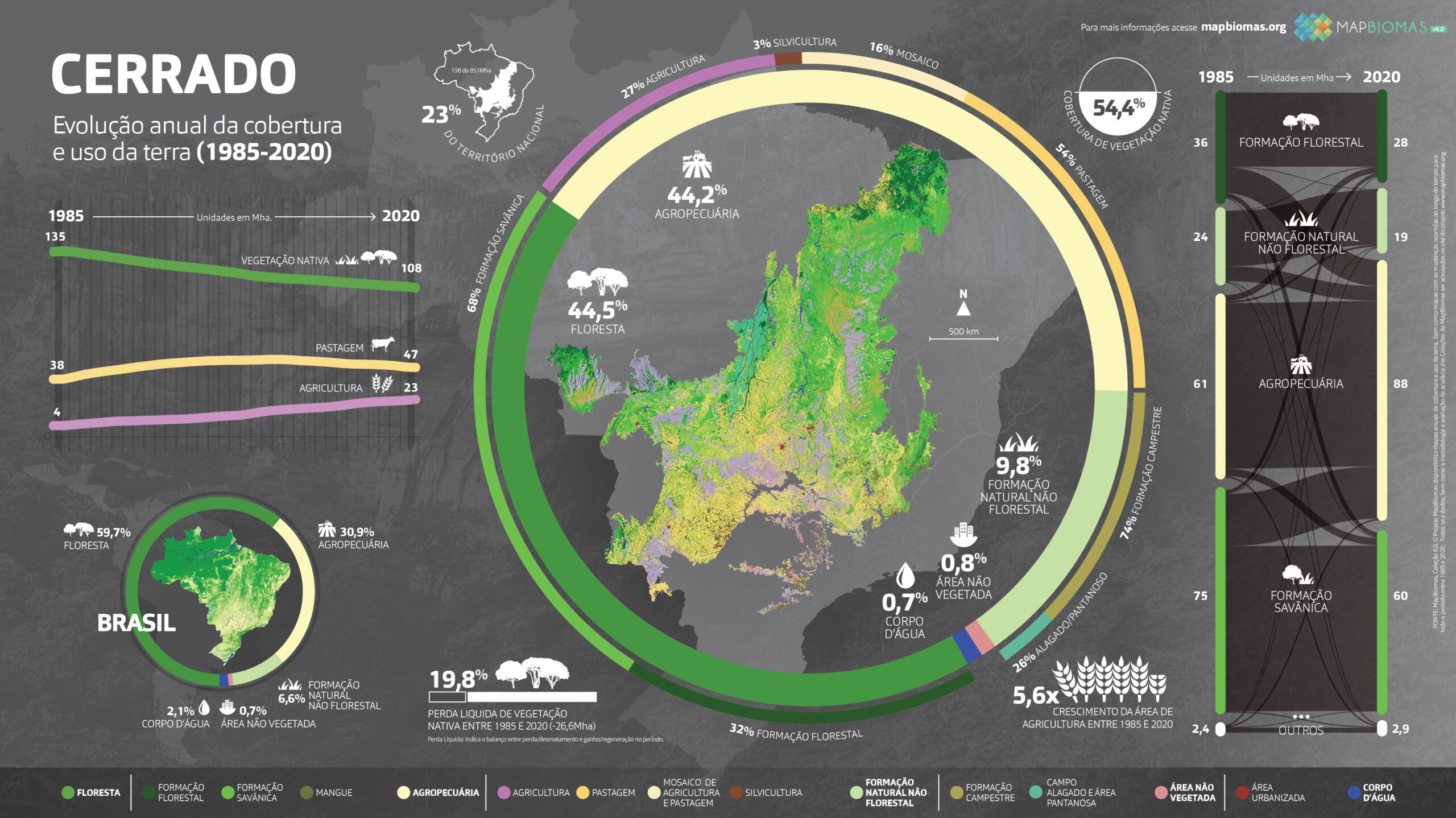
The Matopiba region, a Cerrado area covering the states of Maranhão, Tocantins, Piauí, and Bahia, more than doubled the area allocated to agriculture in the last 36 years. With an increase of 258%, it went from 5.6 million hectares to 14.6 million hectares dedicated to the activity, an area larger than that of the state of Amapá. The data comes from the new collection of the MapBiomas initiative and was presented at a specific event for the biome on Friday (10), on the MapBiomas Brasil YouTube channel.
In addition to the numbers, satellite images show the impacts of intensified deforestation and agricultural activity. Leading in the relative increase in agricultural area in the Cerrado, Bahia quintupled this type of land use from 1985 to 2020. Meanwhile, Piauí tripled the agricultural area in the biome's region starting from the late 1990s. Tocantins experienced the greatest loss of native vegetation in the Cerrado in the last ten years (1.11 million hectares), followed by Maranhão (890,000 ha).
"The data clearly shows an accelerated process of conversion of natural areas in Matopiba, as previously observed in other states of the Cerrado," explains Julia Shimbo, scientific coordinator of MapBiomas and researcher at IPAM (Amazon Environmental Research Institute). If total loss of native vegetation since 1985 is considered, Mato Grosso leads with 6.8 million hectares, followed by Goiás with 4 million hectares, and Mato Grosso do Sul with 3.4 million hectares."
The Cerrado is the second largest biome in Brazil, covering 198 million hectares, and it presents different types of native vegetation. As a biodiversity hotspot, it is the most biodiverse savanna in the world and is under a high degree of threat. Almost half has already been deforested: 54.5% of its territory is still covered by native vegetation, with 44% located precisely in Matopiba.
What remains in the Cerrado is distributed across different formations. The main ones are savanna (30.3%), forest (14.3%), and grassland (7.3%).
Biome in crisis.
From 1985 to 2020, the Cerrado lost 19.8% of its native vegetation, equivalent to 26.5 million hectares, which is an area larger than that of Piauí. The expansion of agriculture in the biome during the same period is almost complementary: 26.2 million hectares were allocated to this activity. Currently, agriculture occupies 44.2% of the Cerrado.
One of the novelties of Collection 6 of MapBiomas is the inclusion of the new class of wetland areas in the Cerrado, such as wetlands, gallery forests, park savannas, and marshes, which represent 2.5% of the remaining areas. These environments have also undergone transformations: 582,000 hectares have been lost since 1985, accounting for a 10.3% loss of wetland areas. Of the converted area, 61% was allocated to agriculture, especially pasture, and 32% turned into another type of vegetation, such as grassland, savanna, and even forest.
About MapBiomas
Multi-institutional initiative that processes satellite images using artificial intelligence and high-resolution technology in a collaborative network of experts, universities, NGOs, institutions, and technology companies to create historical series and mappings of land use and land cover in Brazil. IPAM is the institution responsible for mapping native vegetation in the Cerrado biome within the MapBiomas network
Access the main highlights of Collection 6 of the Cerrado biome..
Download the infographics here:
Learn about the presentation of Cerrado data: